
 Tomorrow I’m reluctantly moving on from my lovely apartment in Les Gets towards Zurich so that I can meet my big brother & nephew next weekend for a 70th birthday bash (and I’ve heard a whisper it’s his wife’s birthday too 🙂 )
I’m fully recovered from the ride here and the excellent Thierry has fitted the bike with new chain, rear gear cassette and brake pads. The dreaded rear pannier’s have been despatched home with my neighbour, as I’ve been assured by Sally after speaking to Pete that a tent isn’t necessary 🙂
I’ve spent the last few days trying to sort out my Etrex 20 with maps and in a moment of sheer stupidity lost my OSX application library – which interestingly broke all my Chrome extensions in a very nasty way, the dangers of using an offline backup service. 🙁
NB: All that follows is for Mac OSX users.
What I’ve learnt about Garmin maps is that you can fill your Garmin Etrex up with highly detailed Open Street Maps, essentially for free by visiting Velomap and downloading the desired country(s). Installing Garmin Basecamo & Garmin MapInstall. Unzipping the maps using The Unarchiver, setting the destination to the Application Library/Garmin /Maps folder (be careful here!).
Then using Mapinstall pop them into the Garmin. I now have all of France, Germany, Switzerland, Germany, Austria, Slovakia, Croatia, Serbia, Hungary & Romania installed on my recently purchased 4GB micro SD (€8 from GITEM in Morzine).
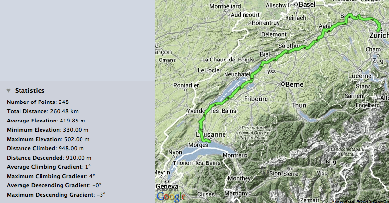
To work out the routes I’ve been using Bikemap to create a track. A tip here if you want to modify someones existing track, download the gpx file to the desktop, create a new track in Bikemap and upload the gpx file, then you can edit it. To make the track into a route I used the cool JavaWa tools. I then used Basecamp to stuff the route into the Etrex. Tomorrow is the test 🙂
However, that’s only the backup sorted :-). What I really will use is the iPhone and the Gaia app, I’ve uploaded the tracks to the iPhone via email. Then used the neat Gaia utility to auto download the relevant Open Street Map tiles to the iPhone that cover the tracks, so in theory it all works offline.
Apologies to anyone tracking me but my SFR MiFi unit has used all it’s 2GB of data so I’m off air until I can reach a SIM shop in Switzerland…

All sounds very complicated but will be worth the effort have been playing with bikemap myself … will pray i gave you right info about tent but i am big enough to take the blame :-)… enjoy your ride stay safe and see you in Budapest 🙂 🙂
I’m sure it will be OK to Budapest – it was only the 1000 miles after that it may be a problem…
I keep checking pete’s updates and he is well passed Budapest now and still ok with out tent … he has done 60 days with another 30 to go.
Please keep safe x
Excellent! Good ride down to Evian except for mega trucks 🙁 smooth crossing on the lake. Bike & me much better without panniers 🙂
Have a good trip , looking forward to seeing your photos on the way .