
 Interesting to find a couple of old reports on ‘freak weather’ in Whaley Bridge 147 years ago.
Whaley Bridge is mentioned twice in the flood chronologies for events in June 1872 and July 1881:
On 19th [June 1872] the Goyt was 12 to 14 feet above its normal level. At Whaley Bridge houses near the river were completely flooded and people were taken into the chapel and inns … in Macclesfield a woman and child were drowned when the river Bollin overflowed. Two reservoirs burst in the vicinity.
From: https://theconversation.com/heatwaves-and-flash-floods-yes-this-is-britains-new-normal-121351
The summer of 1872 was a wet and exceptionally thundery summer with frequent and at times severe thunderstorms.
Some reports of the thunderstorms that occurred during that summer.
18th June 1872
Chesterfield: Severe thunderstorm at night
Macclesfield: Thunderstorm lasting 12 hours.
From https://www.netweather.tv/forum/topic/62652-the-very-thundery-summer-of-1872/
 Still, we managed a quick ride from Buxton down The Goyt after a couple of very very wet days with the overflow at the Errwood Reservoir in full flow
Update 5 Aug 2019
December 1964
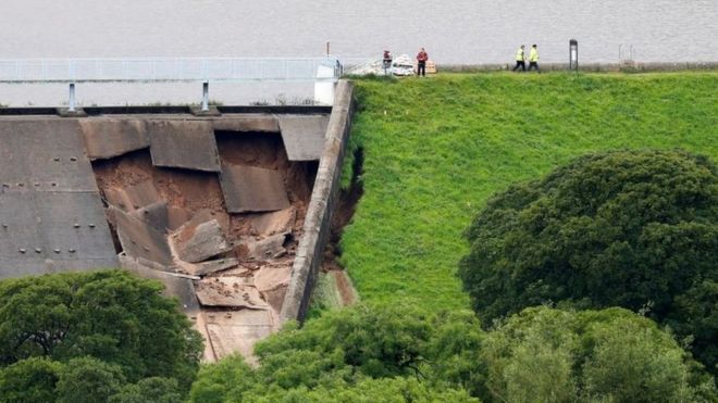
Toddbrook Incident date: December 1964 Construction details The reservoir was constructed in 1840-41 to supply water to the Peak Forest canal. It is on the north-west edge of the Peak District National Park near Whaley Bridge. The embankment is 24 m high with 1:2 upstream and downstream slopes. Further details of the dam construction are given in Incident No. 23. Incident description The water level was one metre above the spillway crest for a period of 24 hours following heavy rain and it took another two days for the level to fall to normal top water level. Damage was caused to the lower part of the spillway channel. Some parts of the side walls were washed out and some erosion took place on the right bank adjacent to the downstream toe of the dam.The main deterioration was caused by excessive flow down the spillway. Response The 1964 flood damage was repaired in 1965 and subsequent flood studies confirm the spillway was inadequate to take the design flood. An additional spillway was built in 1969 with a 75-m weir built over the southern section of the embankment discharging over a concrete-protected portion of the downstream face. The sill level is above the original spillweir level. Lessons The incident showed that despite the dam being in existence since 1840, the spillway was inadequate. The incident instigated a flood study of the reservoir resulting in an additional spillway constructed.
Charles, J Andrew; Tedd, Paul; Warren, Alan. “Delivering Benefits Through Evidence Lessons from Historical Dam Incidents”. environment-agency.gov.uk. Environment Agency. p. 140. Retrieved 1 August 2019.
From: https://obiterj.blogspot.com/2019/08/emergency-at-toddbrook-rservoir-whaley.html
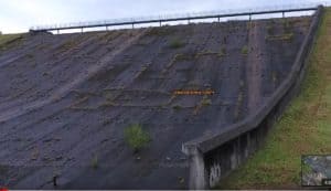
Left is an interesting video from Miles Haslam showing the spillway in August 2016 with a small tree growing in it at the point that recently failed ! and on the right with a photo during the recent overflow showing the same tree 3 years later! 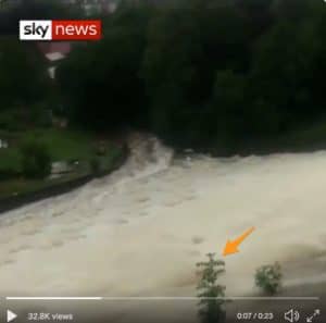

Good luck to all in saving this threat