Inveterate dabbler in business, travel, gadgets & life

Cambridge Rambling Club – Audley End ramble

Today’s ramble with the Cambridge Rambling Club A team started further afield 🙂

The start was at Audley End, Vera led 13 of us, at a cracking pace, across the rolling Essex countryside to The Langleys were we stopped for our sandwiches outside the The Bull. Tea was taken alongside the stream in the very pretty village of Arkesdon.

The countryside was still very wintry & bleak looking with only an occasional burst of snowdrops to brighten the day a little.

Audley End to Langley walk

Widget powered by EveryTrail: GPS Geotagging

We did just over 16miles in 5hr 11min of moving time with 1hr 35min of stops. Surprisingly for us flat landers we did 0ver 1900ft of ascent!

Graph of elevation and speed, from HoudahGeo
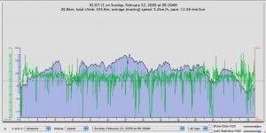
Walk elevation & speed

Muddy Boot day

After my hectic night with Sally (see her posts here and here) plus stopping to take a snapshot of  one of the three police cars wrecked on Regent Street we didn’t make it back home till 1am ish.

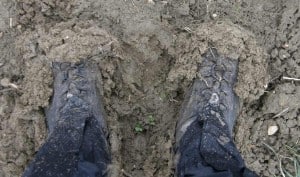
Mud, Mud glorious mud

Then today was up and away to be at Cambridge Rambling Clubs ‘A’ walk led by Carolyn with a 9am start from Hardwick across the total overkill of the blue footbridge over the A428  followed by many many muddy fields to Elsworth for a drink at the George & Dragon run by the aptly named Mr & Mrs Beer.

Here is the walk with some great shots of muddy boots:-

Cambridge Ramblers – Elsworth Walk

Widget powered by EveryTrail: GPS Geotagging

My Odd Job day

Today was repair Sally‘s bed day 🙂 Necessitated by her 6ft+ lad falling on her foot board when playing hide and seek 🙂 and cruelly snapping it in two.

Good excuse for me to try out my new Erbauer ERB800RL all purpose saw – worked fine although I think it may be to flimsy for the more severe pruning jobs that friends ask me to do!

After which Sally gave me a first rate Indian Head massage and then I installed the new Google Latitude (alas not fully functional for us second rate citizens in the UK) programme whilst Sally had a paying client for a Swedish massage.

We headed off to Kings Lynn for a short walk and tea with Sally’s friend who did the Inca trail a couple of years ago.

Here’s the walk using the very neat Everytrail application on the iPhone:-

Lynn stroll

Widget powered by EveryTrail: GPS Geotagging

Cambridge -Anglesey abbey circular walk

Today’s walk was a 17 or so mile circular tour from Cambridge along the tow path to Baits Bite lock and then across to Horningsea. We then ventured across Quy Fen to Anglesey Abbey to see the Himalayan Siver Birch trees resplendent with their jet washed bark 🙂 We returned alongside the lovely mill stream to Quy had a pint & cuppa at the Quy Mill Hotel before going under the A14 to return home via Teversham and Cherry Hinton.

I was experimenting with the new iPhone GPS application called Trail, this worked very well even with the iPhone stuffed in the breast pocket of my jacket! Once completed you can email the gpx file or send it directly to Everytrail.

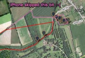
Missing track

Problems are battery life – my estimate is 4 hours – although apparently you can trick it into shutting the screen down by having the music playing 🙂

The second problem is that you can lose significant bits of trail by the software automatically connecting broken tracks together. See the purple trail I’ve added in the image.

Definitely worth having the capability as my Garmin Etrex batteries ran out during the walk! Trail also allows you to view your Everytrail tracks. Overall pretty neat and impressive that it works with the iPhone in my pocket. Thanks Euan for the tip

Here is the completed trail with photographs :-

Cambridge to Anglesey abbey circular walk

Widget powered by EveryTrail: GPS Geotagging