Inveterate dabbler in business, travel, gadgets & life

Offas Dyke Path

Today finds me waking up in Cloud Hill, a late 60s architect designed house, lots of plywood beams and clean open spaces.

I’ve now walked 76km of the 282km path and had my leg over 100 stiles. So far from Prestatyn it’s been very hilly but today’s walk from south of Llangollen to Four Crosses looks slightly easier 🙂

Managed to lose the neoprene surround from the GPS yesterday so now have to operate it with a cotton bud!

Time for brekkie now….

Planning…

Busily planning my next little hiking trip, which has to take less than two weeks, so I can be back to take Emily of to Sussex to start her three years of partying 🙂 Sorry, university!

Here is the elevation plot of the proposed trip taking using memory map:-

Pretty bumpy, should be interesting, More to follow…..

Cambridge to Les Gets the final map.

After much effort with dodgy computers I’ve stitched together all 10 days of my travel to Les Gets. Joost at Everytrail listened to their customers and have now enabled importing pictures from Picasa. So here is the trip with all the photos beautifully geotagged. The GPS data is down to street level so you can see every turn and mistake I made.

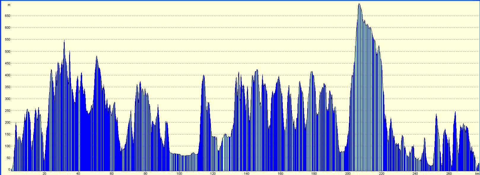
Unfortunately the GPS height data is very ‘noisy’ and Everytrail doesnt seem to have any statistical smoothing,  so the ascent/descent numbers are  wildly out. It says I climbed 57,653 feet and descended 56,402 feet 🙁 (Although the overall effect is not bad as it implies I’m at 1251 feet whereas I’m at 3800 feet) However, the trip profiles are correct.

The cyclometer displayed a distance of 779 miles and the GPS 801 miles, The boat covered 21 miles where i didn’t pedal 🙂 So pretty amazingly the correlation was spot on!

The moving average for the whole trip was 10.7mph and the overall average including stops when travelling was 7.9mph. So my biking is just over 3 times faster than me walking!

Here it is:-

Cambridge to Les Gets bike ride

Widget powered by EveryTrail: GPS Trip Sharing with Google Maps

I made it to Les Gets on my bike!

On the Tenth day I made it to Les Gets by 4pm. Two Cols climbed with  a total ascent of over 6000 feet (two Ben Nevis’s nearly) and a distance of 70 miles. Not bad at all, the total journey came in at 779miles.

The weather stayed fine so I managed to stay warm the N5 was not to busy so not as scary as I thought and the mega descent to Lake Geneva was great as the route is not used by trucks.

Now to work out how to get home! Here is todays trip:-

Day10 – Morez to LesGets

Widget powered by EveryTrail: GPS Trip Sharing with Google Maps