Day 10 on the GR5
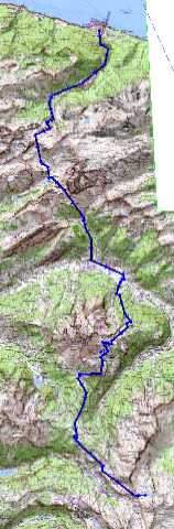
Made it to Val D’Isére today on my 9th walking day from St Gingolph on Lake Geneva. The new Scarpa boots I bought in Chamonix en-route are great, my heel blisters caused by the Raichle boots I bought in Cambridge have now disappeared.
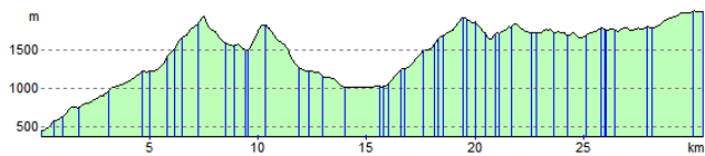
The vertical ascents on this route are amazing. My prediction is it will be equivalent to 3 or so Everests by the time I reach Nice. Today it was a straight climb of 3600ft after breakfast followed by another 700ft from Tignes to here.
I’ve now walked about 140miles or around 37% of the journey in 9 walking days. So maybe i will walk it in 22 days as the sign said.
Tonight its deluxe comfort in a REAL hotel (The Hótel Le Relais du Ski -only one open in thus huge resort) with soap and towels, instead of a refuge with their communal dorms and single tepid shower! Question is will I wake up to do the 3200ft climb to the highest point on the GR5 and escape this valley first thing tomorrow.
Interestingly I have now met three sets of folks from Kendal on this trip.
Philip you are welcome to try it on a bike but the fixed ladders on a couple of the rock faces may represent a challenge as would the 2 foot wide ledge for about a mile with a vertical drop of around a thousand feet and dont forget the boulder fields as well 🙂
The weather is great with rain and thunderstorms only at night. Lets hope it stays that way.
Many thanks for all your texts it is appreciated especially since I havent seen another walker all day!
Cheers and Love
Geoff
and especially for Emily
Xxxxxxxxxxxxxxxxxxxxx