Inveterate dabbler in business, travel, gadgets & life

Days 11 & 12 on GR5

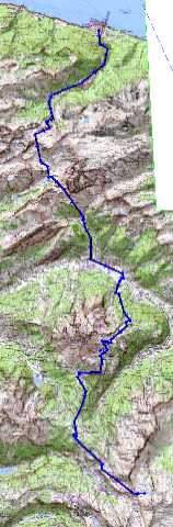
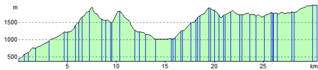
Today the weather broke and I walked in rain all day to Modane , 17 miles in less than 6 hours with only one stop. The going was easy on the GR5E with only about 500ft or so of climbs all day from Lanslevillard.

I kept reasonably dry, the Scarpa boots kept my feet really dry (obviously made the right choice, especially since they are George & Jacqui’s favourites too) The RAB Bergen jacket ‘Dry Inside’ tm. Didnt quite live up to its hype with both arms getting wet and the pocket contents (goodbye FFRP guide) getting soaked. I wouldnt count today as extreme either, being valley and forest walking.

The trip yesterday from Val D’Isére to the highest point on the GR5, Col D’Iséran at 9068ft was excellent (a 3200ft climb) I took the easy GR5E route from Bonneval-Sur-Arc down to Lanslevillard (great for cyclists, Phillip).

Body holding up well, all blisters gone and only a burning right heel, which a splodge of Nurofen max. Strength gel (thanks Pennine Way Chris) seems to have worked. Interestingly I can feel my heart working harder once I get over 2500m so maybe the Inca trail is not for me…

Caren no luck yet, although a couple I met a couple of days ago said I wouldnt stand a chance if I continued to roll two walking days into one!

Peter, pleased the new hip is working well. I remember Middleton well from the Pennine Way 6 months ago.

Tomorrow its back to the hard core GR5 with a 4500ft climb out of Modane followed by a 2500ft drop to the refuge, no more hotels for a while…

Think I’m about half way now. 175 miles in 11 walking days, so the 22 days on the sign near La Chappele seems feasible.
Cheers and love
Geoff
and for Emily (if you are getting these missives) xxxxxxxxxxx

Day 10 on the GR5

Made it to Val D’Isére today on my 9th walking day from St Gingolph on Lake Geneva. The new Scarpa boots I bought in Chamonix en-route are great, my heel blisters caused by the Raichle boots I bought in Cambridge have now disappeared.

The vertical ascents on this route are amazing. My prediction is it will be equivalent to 3 or so Everests by the time I reach Nice. Today it was a straight climb of 3600ft after breakfast followed by another 700ft from Tignes to here.

I’ve now walked about 140miles or around 37% of the journey in 9 walking days. So maybe i will walk it in 22 days as the sign said.

Tonight its deluxe comfort in a REAL hotel (The Hótel Le Relais du Ski -only one open in thus huge resort) with soap and towels, instead of a refuge with their communal dorms and single tepid shower! Question is will I wake up to do the 3200ft climb to the highest point on the GR5 and escape this valley first thing tomorrow.

Interestingly I have now met three sets of folks from Kendal on this trip.

Philip you are welcome to try it on a bike but the fixed ladders on a couple of the rock faces may represent a challenge as would the 2 foot wide ledge for about a mile with a vertical drop of around a thousand feet and dont forget the boulder fields as well 🙂

The weather is great with rain and thunderstorms only at night. Lets hope it stays that way.

Many thanks for all your texts it is appreciated especially since I havent seen another walker all day!

Cheers and Love
Geoff
and especially for Emily
Xxxxxxxxxxxxxxxxxxxxx

Route Planning

Here is the summary of the first two days walk that I propose starting on Saturday. I intend to follow the GR5 from St. Gingolph on Lake Geneva to Nice.

I’m using , for the first time the memory-map software [Important the Alpes version MMV5/IGN/PE/MB388/CI is faulty call 01189062600  to get a version that has Geneva and St. Gingolph on it]

This enables me to send waypoints (each verical blue line below) to my Garmin Legend. Unfortunately the Garmin can only hack 20 days, so I’m having to merge two days together and at the same time keeping the waypoints below 50. (The Garmin is primitive, computer wise a bit like Palms were 5 years ago!) If only the Treo700 was available in the UK.

The Memory Map software prouces lots of pretties like this below:-

Summary

Route Distance: 30.5 km
Estimated Time: 11:35 Total Ascent: 3654 m
Total Descent: 2091 m

Elevation Profile (St.Gingolph on left, La Chappelle D’Abondance at 15km and Refuge de Chesery at 30.5km.)

Weather wise, I see the zero isotherme in Chamonix is at 2000 -> 2600 m. Which is the elevation of most of the walk.  Although this is promising:-

High 1025 hpa east of Azores, extending gradually towards Southwestern France. Northwesterly stream over the Northern Alps becoming gradually more stable and dryer. High pressure condition expected to prevail thereafter and at least until the middle of next week.”

Now i must get back to clicking away on my maps.