Inveterate dabbler in business, travel, gadgets & life

Cycling again after 40 years……

Its been in my head for a long time to cycle down through France, in fact checking my Quicken I can see that I treated myself to a new bike for £669.98p for my birthday 10 years ago! A bike that has not been used for over 9 years ……

Finally I’ve decided to bike to my ski apartment in Les Gets, not in the winter season 🙂 but in the next few weeks. As the crow flies its 800km or about 500miles. After enduring Peruvian and Ecuadorian driving for the past few weeks I’m pretty well OK with roads now…..

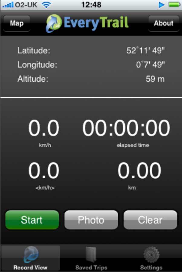
The bike is booked into Howes, on my birthday, in a couple of weeks, to get it into shape, in the mean time I thought I would get myself into shape by doing a bit of training. Here’s today little ride of 21.5 miles cycled at 12.5mph so not bad as a starter 🙂

Watlington to Gayton bike ride

Widget powered by EveryTrail: Share GPS Tracks>Watlington to Gayton bike ride

Blackpool to Edinburgh
Les gets
Dover to Les Gets

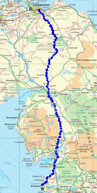
In my youth my longest ride in a day (I was about 17/18)was the 200miles from Blackpool to Edinburgh and doing 100mile days was pretty normal at the weekends,  so lets see if the leg muscles have weakened with age.

Boarding in Les Gets

Today has been glorious here in Les Gets, bright sunshine helping to offset the -8 degrees temperatures.
I took my board out for a 28mile ride going up 13 lifts totalling about 3 vertical miles of ascent 🙂 Top speed recorded on the GPS was 34.7mph. I felt really comfortable motoring along, either I’m getting better or the snow is real good. The LH K2 binding is still a bit of a struggle to clamp in – maybe I need more stretching exercises to get down there easier!

Here is the Everytrail and photos. :-

Boarding in Les Gets

Widget powered by EveryTrail: GPS Geotagging

Out here I’m using my old Toshiba Tablet So I’ve had to install GPicSync to geotag the pictures from my Olympus SP560UZ.

Happy New Year and our first walk

A Happy New Year to all my readers 🙂 Good to see that you are a person of excellent taste and recognise a real quality blog!

After spending the first 12 hours of the new year in bed with Sally we decided a walk was in order. Neither of us could face the annual new year swim in the river.

So we decided to walk the opposite way and go to Baits Bite Lock via Chesterton and then return via Fen Ditton.

Here is the route with photographs. The GPS is a bit wonky in places,  as I kept it in my pocket so reception was poor under the willow trees 🙁

Baits Bite Lock walk

Widget powered by EveryTrail: GPS Geotagging

In the process of trying to tidy up the GPS traces I stumbled across TrailRunner which looks quite interesting and may replace the rather expensive Ascent package that I currently use. Here is a screenshot of it with today’s walk:-

TrailRunner screenshot

Another bit of software than Euan suggested was Trails for the iPhone, it certainly pulled in my Everytrail walks pretty neatly 🙂

EverTrail on the iPhone

Another day another new iPhone application. Today it was EveryTrail.

In the past I used my Garmin Etrex as a GPS and a regular camera, by fiddling with LoadMyTracks, HoudahGeo and Flickr I managed to upload my walks to Everytrail. Today it all changed 🙂

Here is my test walk around Cambridge with the iPhone:-

cambridge station walk

Widget powered by EveryTrail: GPS Geotagging

EverTrail iPhone screen

On the iPhone the application looks like this, very intuitive to use, give it your login name ad password then just walk and take pictures. It isn’t using the cell networks or WiFi so these can be switched off. I didn’t and the iPhone battery was dead in about 2 hours 🙁

Battery life is a real issue with all these new applications, it means its a playphone rather than a real tool for saying doing day long hikes.

Other than that its a great little application – the log was uploaded over WiFi in a few minutes at home.

It could be improved by having the screen shut off and some positive indication that it is locked to the satellites, maybe buzz if it loses the GPS signal. A screen showing satellite positions and strengths would be cool too. I also noticed that it lost the Altitude data when transferring to Everytrail – not so bad in Cambridge but annoying on a mountain walk.

Apologies for poor image quality – obviously a sticky finger left some traces on the camera lens – a snag when you have to hold the phone for so long!

A good free application that is really only limited by the poor iPhone batteries and satellite receptio.

Powered by ScribeFire.