
Here is the summary of the first two days walk that I propose starting on Saturday. I intend to follow the GR5 from St. Gingolph on Lake Geneva to Nice.
I’m using , for the first time the memory-map software [Important the Alpes version MMV5/IGN/PE/MB388/CI is faulty call 01189062600 to get a version that has Geneva and St. Gingolph on it]
This enables me to send waypoints (each verical blue line below) to my Garmin Legend. Unfortunately the Garmin can only hack 20 days, so I’m having to merge two days together and at the same time keeping the waypoints below 50. (The Garmin is primitive, computer wise a bit like Palms were 5 years ago!) If only the Treo700 was available in the UK.
The Memory Map software prouces lots of pretties like this below:-
S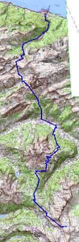 ummary
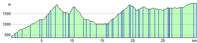
Route Distance: 30.5 km
Estimated Time: 11:35 Total Ascent: 3654 m
Total Descent: 2091 m
Elevation Profile (St.Gingolph on left, La Chappelle D’Abondance at 15km and Refuge de Chesery at 30.5km.)
Weather wise, I see the zero isotherme in Chamonix is at 2000 -> 2600 m. Which is the elevation of most of the walk. Although this is promising:-
“High 1025 hpa east of Azores, extending gradually towards Southwestern France. Northwesterly stream over the Northern Alps becoming gradually more stable and dryer. High pressure condition expected to prevail thereafter and at least until the middle of next week.”
Now i must get back to clicking away on my maps.

It would be good if you could elecontronically tagged to your PC so we could monitor your movements – real Big Brother stuff!
Good luck with the walk, it sounds fantastic, very arduous.
Geoff, Bon Voyage, and take care…